Registration is open for the @PALSEAgroup and @OnSea_Inqua workshop "Warmer coasts in a warming world" which will take place in beautiful Venice between 19-21 June 2025.
Register and submit abstracts by 15th March at bit.ly/4kkwHWl@INQUA@INQUA_ECR@INQUA_CMP
Soooo useful:
Following Richard Styron's walkthrough, Efstathios Lymperis has written a plugin for plotting beachballs in @qgis!
plugins.qgis.org/plugins/qbe…
🙏
Just submitted to OnSea's @EuroGeosciences session and looking forward to a great meeting in Vienna. Waiting time in "the abstract lobby" was just under three minutes 😅
Look! You are a seismic sensor: when you feel a tremor and launch the LastQuake app,we know that an #earthquake (#potres) might have occurred👇LastQuake launches before🟠 and after 🟣 the app notification about the #earthquake (#potres) in #Ljubljana 11 min ago.
I really enjoyed meeting a lot of old and new colleagues and was especially impressed by the great work done by ECRs from our community. Hope to see you soon somewhere!
Great two days at the 1st #OnSea meeting at @univpaulvalery in #Marseille and in the @MuseeEphebe in #Agde. A big thanks to all the great presentations from the participants and all the interesting discussions. See you at the next OnSea event!
We are searching for evidence of past earthquakes along the Raša Fault in SW Slovenia and are currently working in trench no. 2. This time, the fault is playing hide and seek with us.
#Paleoseismology#ActiveFault
It's the Olympics and of course we have geology for you.
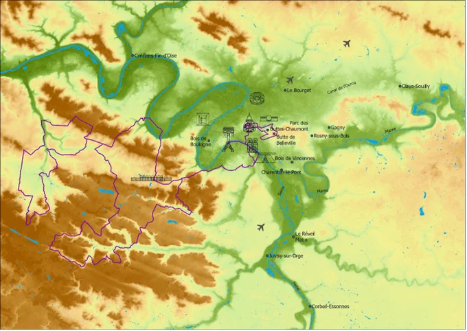
The Seine river, where the opening ceremony is tonight, shaped the city of Paris and its surroundings.
Where it had no room to flow, it flattened the land where we now see Versailles and the Equestrian events or, of course the time trials on Saturday, but where the Seine and also the Marne did have room, it left the hills alone.
The Butte de Montmartre which will be part of the road races is one of those hills the Seine didn't 'eat up' so we get some elevation there.
Enjoy the geology of Paris by Geneviève Spits.
geo-sports.org/2024/the-geol…@knag@UUGeo@UniUtrecht@TNO_nieuws#Paris2024
Zadnjo etapo letošnjega tura bodo kolesarji za spremembo zaključili v Nici. Današnji blog pa se sprašuje, ali se Alpe zaključijo na cilju ali pa jih morda najdemo tudi pod Sredozemskim morjem. #tdftvs
On the final day of the Tour de France, we are back at the Mediterranean Sea. We already learned that it once was completely dry and like salt flats. Remember the Messinian Salinity Crisis of stage 2?
Today we go deep under the shiny blue waters and find out if the Alps just suddenly end at the coastline of Nice or whether they somehow continue underwater.
Well, I think we already spoiled it. The answer is indeed yes, the Alps do continue underwater all the way to Corsica. The reason behind this is a geological tale of twist and turns.
On stage 21 Maria di Rosa of Università di Pisa looks at the plate tectonics once more and finds out what happened underneath the shiny blue waters of La Mediterrannée!
geo-sports.org/2024/stage-21…#TDF2024#GeoTDF@knag@UUGeo@UniUtrecht@TNO_nieuws
V predzadnji etapi bodo kolesarji prečkali dolino reke Vésubie, ki je pred štirimi leti bila prizorišče hude naravne nesreče. ⬇️⬇️ o, žal tudi pri nas, zelo pogostem geohazardu alpskih dolin - pobočnih masnih premikih #tdftvs
In 2020 catastrophe hit the Vésubie valley, the place we race today.
Sediments from the river caused major damage we still see four years later along the course of stage 20. Theo, Loïs and Adèle explain what happened when storm Alex hit here on 2 October 2020.
To explain why it did so much damage we travel back in time to explore the specific geology of the region and how that attributed. Glaciers played an important role in the now sunny part of Southern France.
But the scientists at @inrae_france also look at the future and how such a disaster could be prevented from happening again.
@knag@UUGeo@UniUtrecht@TNO_nieuws#TDF2024#GeoTDFgeo-sports.org/2024/stage-20…
Danes bodo kolesarji prečkali najvišjo točko letošnjega tura, zato je zelo primerno, da se današnji Geoblog sprašuje, kaj je višina in zakaj so na isti točki višine na naših pametnih urah, GPS-jih, Stravi in na različnih kartah različne. #tdftvs
How high is high is the question I (@josebeentv) had before this year’s Tour de France when looking at the mountain stages.
Today’s stage 19 has special significance because it crosses the highest point of the year. It’s called the Cime de la Bonette so a perfect stage to answer that question.
@cataclasite of @UVU@UVUEarthScience explains this difficult subject by using the science of geodesy. We go into space, but we also take the air pressure down here into account. How come your bike computer is sometimes completely off with the meters of elevation you rode?
Why is it important to know the density of the mountain and what is a geoid or ellipsoid?
It all sounds super complicated but trust me, it’s very fascinating and completely clear after you read today’s blog.
@knag@UUGeo@UniUtrecht@TNO_nieuwsgeo-sports.org/2024/stage-19…#TdF202
In case you wondered how this ‘chimney landscape’ formed:
It’s called badland erosion. Thus is a sequence with thick layers of weak rocks (clays) and some beds of hard, durable rock (sandstones). The clays below the sandstones are protected from erosion, but once the sandstones are removed, erosion goes quick.
So the tops of the chimneys are remnants of the sandstones, and the pilars are clay.
I wouldn’t build my house underneath one…
@BoogerdLive
Alpe še vedno rastejo! Na trasi današnje etape se dvigajo skoraj s hitrostjo dveh milimetrov na leto! ⬇️⬇️ več o vzrokih in kako merimo premike zemeljske površine #tdftvs
Ready for an uplifting story?
The Alps of stage 18 are still getting higher. Yes!!
Will the riders have to climb even higher next year? Well, only just a fee millimeters but still.
How is it possible the Alps still get higher? How do we even know that they do?
Peter McPhee explains us how the Alps are where they are in the first place (spoiler: it’s tectonics).
He explores why the mountains still get higher. Ice ages and ice bergs are unlikely reasons but do play an important role although it’s not all.
There is always more to it….
#TDF2024#geoTDF@knag@UUGeo@UniUtrecht@TNO_nieuwsgeo-sports.org/2024/stage-18…
Današnjo etapo bodo kolesarji zaključili na vznožju masiva Vercorsa - naravne trdnjave, ki je odigrala pomembno strateško vlogo v 2. svetovni vojni. ⬇️⬇️ o vplivu tektonike na vojaške konflikte in tudi lahkotnejša tematika o tartufih na apnencih #tdftvs
Today’s Tour de France route crosses the Vercors, a region rich in geology. This is #GeoTDF after all. We wouldn’t be here if there was nothing to say.
In this region, the geology of the landscape leads to gastronomic highlights and historical events, namely the truffles and maquisards.
The Tour de France peloton can hope for a taste of limestone-grown black truffles. Where would we be without limestone?
The maquisards, the French resistance in WWII, used the rugged nature of the Vercors as a natural fortress.
The specific geomorphology and geological history explain why the Vercors Massif was a highly disputed strategic military bastion during WWII and a shelter for French resistance.
Will the green jersey also be able to defend his lead today in the Vercors?
Leny Montheil of @Cerege_officiel takes us to the bottom of it once more on stage 17 of #TdF2024.
@knag@UUGeo@UniUtrecht@TNO_nieuwsgeo-sports.org/2024/stage-17…