
CloudCast is now in open beta. Why settle for another ordinary weather app when you could be among the first to experience something different? Download CloudCast today and get early access. testflight.apple.com/join/4R…
0:40
 Open web. Clear feed.

UK weather and climate updates | Long range weather forecasts based in atmospheric dynamics | Weather chart creator
CloudCast is now in open beta. Why settle for another ordinary weather app when you could be among the first to experience something different? Download CloudCast today and get early access. testflight.apple.com/join/4R…
COMING SOON I’ve just purchased more server storage and processing cores which will allow me to unlock all the charts and models currently in the app + implement more. The app is still pending Apple approval, but will be submitting a big update with a lot of improvements as soon as it’s approved.


Potential for some localised wind gusts of 50-60mph along the extreme south coast tomorrow as a tightly wrapped low moves east!


As a weather account.. I support this.
Nobody knows weather like we do. That’s why @rockstargames gave us an exclusive look at the forecast for Leonida and the dynamic weather in GTAVI. “Grand Theft Auto VI takes place in Leonida – a fictional world inspired by modern-day Florida, a landscape with one of the most unpredictable weather systems in the US. To match the fidelity of all aspects of what is the deepest, most immersive take on the Grand Theft Auto series yet, we had to completely reimagine our in-game weather systems to feel more localized, persistent, and above all dynamic. Weather can range with everything from clear blue skies to towering vertiginous cumulonimbus clouds, grounding players in a world through weather we hope Florida locals - and new visitors to Leonida - can appreciate.” – Owen Shepherd, VP of Art: Light and Rendering, Rockstar Games. Welcome to Leonida. 🌴
The precipitation type radar is showing snow over the hills of Wales this evening & some sleet elsewhere. The radar is free. Download the TestFlight to try it out 👇🏻 testflight.apple.com/join/4R…


I’ve been doing some work at optimising CloudCast for larger screens. These will be built into the next TestFlight build, on iPad and macOS you’ll be able to have two cards side by side. Everything will also be less “stretched”.

The Met Office snow warning comes into force at midnight ⚠️ ❄️ Snow primarily above 100-200M where 1-5CM is possible briefly, 5-10CM possible above 300-400M. Wintry.

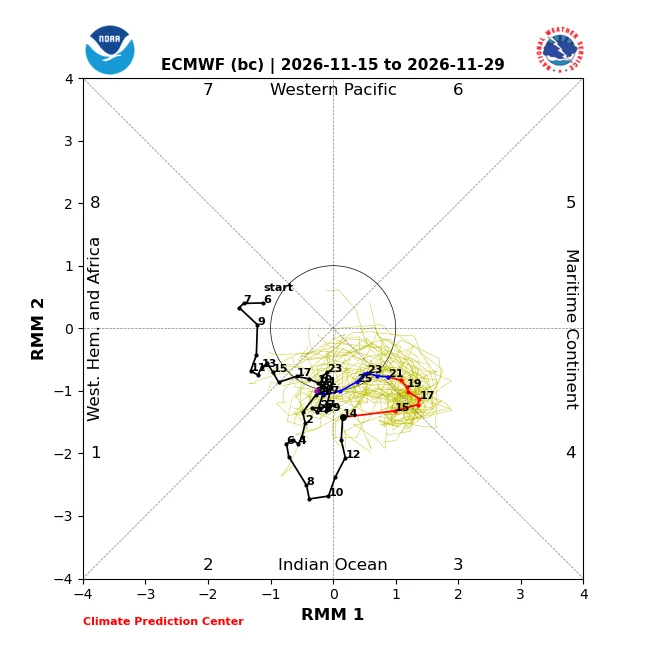
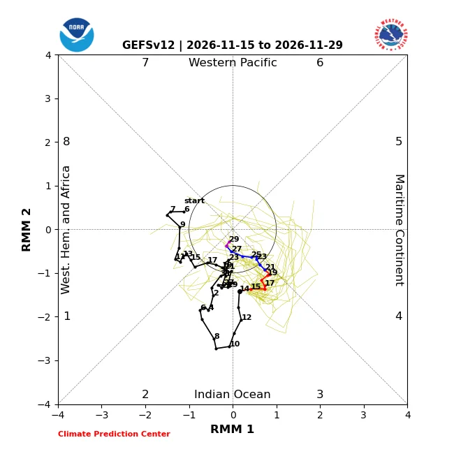
*PERIOD OF INTEREST* A few model runs beginning to toy with the idea of a Scandinavian high towards the end of the month. 28th November - 14th December This is the key period of interest currently as impacts from the slow MJO wave, major SSW + huge addition of momentum to the atmosphere begin to shift global weather patterns. Whether the UK sees a cold spell / snowfall risks remains to be seen, but broadly speaking the potential for blocking over Scandinavia (and then probably retrogressing towards Greenland) is there, and with blocking comes the *risk* of colder weather.

The snow hype of the last week or so has ultimately come down to.. not very much. Some accumulations possible over higher ground but for the vast majority of us tonight.. rain. 🌧️


There was a spell of pretty heavy snow for inland parts of central and northern Aberdeenshire this morning bringing a good covering of snow to some spots. Well predicted by MOGREPS last night. Credit: @Met4CastUK - CloudCast
Weather warnings in CloudCast has a much cleaner look. New TestFlight built will be out tomorrow with the new chart picker + new warnings UI. 👇🏻

One thing catching my eye that might be a bit of a fly in the mash potato is the recent MJO forecasts towards an incoherent signal, i.e a loss of enthusiasm for eastward progression into phase 4 and beyond, perhaps being driven by the +ve IOD, in any case, not particularly what you want to be seeing if you're hoping for further sPV disruption during December. Some models do still favour more robust eastward progression so it's not yet a done deal. Key points: 🔴 Record breaking early SSW on the 10th November Downwelling likely late November / early December 🔴 MJO forecast uncertainty causing long term uncertainty 🔴 Recent AAM rise likely to bring impacts to Europe late November / early December, coinciding with potential SSW impacts, i.e stronger than normal signal for high latitude blocking & colder weather. If we go forward towards the second half of December then the current most likely evolution would be a reversal to +NAO and more of an Atlantic dominating spell, particularly given the rebounding vortex and likelihood of tropospheric imprinting by this point, that said, further sPV disruption could potentially shift the goalposts on this but we really do want to see the MJO pushing through the maritimes and into the west Pacific.

⚠️ SNOW The Met Office have issued a snow warning for the early hours of Tuesday into Tuesday morning.

It’s a rather wintry looking radar just to the north of Scotland ❄️ Meanwhile a soggy evening across more central parts of England and Wales 🌧️

⚠️ ICE The first wintry warning of the season has been issued for tonight with icy stretches possibly leading to tricky travelling conditions.

I’ve re-designed the chart & model picker on CloudCast to make it look and function better, hopefully this will be a little less clunky. Will be in the next TestFlight build.


