
12:03 AM ET 11/12/26: Severe Thunderstorm Warning has been issued for Johnson, Martin, Floyd and Magoffin counties in KY until 12:30 AM EST. Radar shows a storm near Riceville moving ENE; expect 60 mph wind gusts and 1.0" hail. Seek shelter.

 Open web. Clear feed.

Kentucky based Meteorologist, Media Educator, and Nerd.
12:03 AM ET 11/12/26: Severe Thunderstorm Warning has been issued for Johnson, Martin, Floyd and Magoffin counties in KY until 12:30 AM EST. Radar shows a storm near Riceville moving ENE; expect 60 mph wind gusts and 1.0" hail. Seek shelter.
11:38 PM ET 11/11/26: Severe Thunderstorm Warning has been issued for Breathitt, KY & Magoffin, KY & Others until 12:15 AM EST. Radar shows a storm near Jackson moving east; expect 60 mph wind gusts and small hail—seek shelter away from windows.

9:51 PM ET 11/11/26: Severe Thunderstorm Warning has been issued for Barren, KY & Others until 9:30 PM 11/11/26. Radar shows a storm near Rocky Hill moving east; expect 60 mph wind gusts and 1.0" hail. Seek shelter inside.

7:56 PM ET 11/11/26: Severe Thunderstorm Warning issued for Hancock County and North Central Ohio County in central Kentucky until 7:30 PM. Radar-indicated storm near Waitman moves east; expect 60 mph wind gusts and quarter-size hail. Seek shelter away from windows.

7:51 PM ET 11/11/26: Severe Thunderstorm Warning issued for Perry, IN & Breckinridge, KY through 7:15 PM. Radar shows a storm near Patesville moving east; quarter-size hail and winds up to 50 mph. Seek shelter in a well-built structure.

7:45 PM ET 11/11/26: Severe Thunderstorm Warning has been issued for Spencer County, IN and Daviess County, KY until 7:30 PM. At 6:45 PM, a storm near Rockport moved east; expect 60 mph wind gusts and 1.0" hail. Seek shelter.

7:21 PM ET 11/11/26: Severe Thunderstorm Warning has been issued for Perry, IN & Breckinridge, KY & Hancock, KY until 7:00 PM 11/11/26. Radar shows a storm near Waitman moving east; expect 60 mph wind gusts and small hail. Seek shelter.

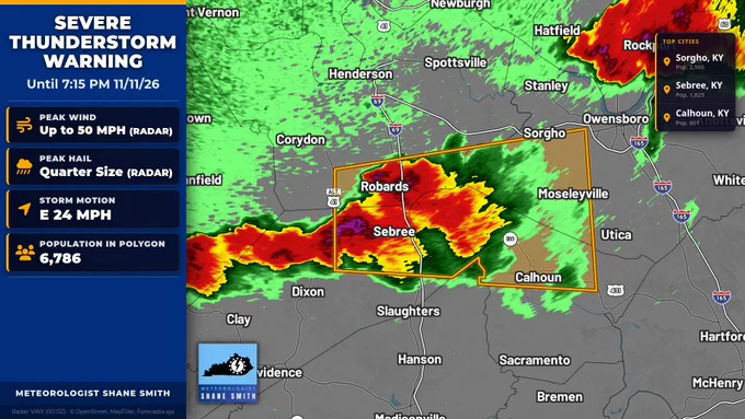
7:16 PM ET 11/11/26: Severe Thunderstorm Warning issued for Daviess, KY & Henderson, KY & Others until 7:15 PM 11/11/26. Radar-indicated storm near Sebree moves east; quarter-size hail and winds up to 50 mph possible—seek shelter in a well-built structure.
7:04 PM ET 11/11/26: Severe Thunderstorm Warning has been issued for Spencer, IN & Warrick, IN & Others until 6:45 PM. Radar shows a storm near Eureka moving east; expect 60 mph wind gusts and 1.0-inch hail—seek shelter in a well-built structure.

6:25 PM ET 11/11/26: Severe Thunderstorm Warning has been issued for Spencer County, IN & Others, valid 5:25 PM–6:15 PM. Radar shows a storm near Newburgh moving east; expect 60 mph wind gusts and 1.0" hail—seek shelter in a well-built structure.

5:52 PM ET 11/11/26: Storms are increasing across the mid-Ohio River Valley, with supercells and some linear segments. Large hail up to 1.75 in and damaging wind gusts up to 60 mph are possible.

4:43 PM ET 11/11/26: Severe Thunderstorm Watch 704 has been issued for Indiana and Kentucky, in effect until 11:00 PM EST. Conditions are favorable for severe storms with damaging winds, large hail, and frequent lightning.

2:21 PM ET 11/11/26: Storms will increase from far eastern Illinois into Indiana and Kentucky through early evening. Hail is likely, some 1.00-1.75 in, with isolated damaging wind gusts up to 60 mph. A tornado cannot be ruled out late day into early evening.

Kentucky Wednesday Storm Threat | Wind, Hail & Tornado Risk, Then Snow C... youtube.com/live/pTIsktboH78… via @YouTube

10:49 AM ET 11/8/26: A Frost Advisory has been issued for Greenup, Carter, Boyd & Others in NE KY, SE OH, SW VA, and central/southern/western WV from midnight tonight to 10 AM EST Mon. Temps near 33F may form frost; cover sensitive plants.

10:02 AM ET 11/8/26: Frost Advisory issued for Fleming, Montgomery, Bath & Others from midnight tonight to 10 AM EST Monday. Clear skies will drop temps to the low-mid 30s, bringing frost that could harm sensitive outdoor vegetation—cover plants.
